
Road Facts
County Highways
Reference Routes
Little Green Signs
Special Features
Interchange of the Week
Travelogues
What's New?
Links
Contact ESR
Visitors since 02/09/01

View Guestbook
Sign Guestbook
HIGHWAY TRAVELOGUES
![[ NY 17 ]](t-17square.jpg) This is a tour of NY 17, one of the longest routes in the State, as it was
originally routed before being transferred to an expressway alignment for
most of its length. The travelogue commemorates the beginning of the end
of the NY 17 designation, which from Pennsylvania to East Corning was joined
by Interstate 86 on December 3, 1999. Upon completion of the Interstate
designation, NY 17 will likely be truncated to the short north-south segment
in Rockland and Orange Counties.
This is a tour of NY 17, one of the longest routes in the State, as it was
originally routed before being transferred to an expressway alignment for
most of its length. The travelogue commemorates the beginning of the end
of the NY 17 designation, which from Pennsylvania to East Corning was joined
by Interstate 86 on December 3, 1999. Upon completion of the Interstate
designation, NY 17 will likely be truncated to the short north-south segment
in Rockland and Orange Counties.
![[ US 20 ]](t-20square.jpg) Before the New York State Thruway was opened, US 20 was the main artery
for long-distance travel across the State. It bypasses most large cities
and is supplemented in this respect by NY 5 along the Water Level Route.
Nationwide, US 20 stretches from the Pacific Coast in Oregon to the city
of Boston, Massachusetts.
Before the New York State Thruway was opened, US 20 was the main artery
for long-distance travel across the State. It bypasses most large cities
and is supplemented in this respect by NY 5 along the Water Level Route.
Nationwide, US 20 stretches from the Pacific Coast in Oregon to the city
of Boston, Massachusetts.
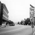
![[ NY 22 ]](t-22square.jpg) At its eastern edge, New York's breadth is nearly as great as its length,
and NY 22 travels the entire distance between New York City and the Canadian
border, the only highway other than Interstate 87 to do so. Hugging the
state line, it avoids large cities and is a secondary corridor to the
more congested US 9, some distance to the west near the Hudson River.
At its eastern edge, New York's breadth is nearly as great as its length,
and NY 22 travels the entire distance between New York City and the Canadian
border, the only highway other than Interstate 87 to do so. Hugging the
state line, it avoids large cities and is a secondary corridor to the
more congested US 9, some distance to the west near the Hudson River.
![[ NY 97 ]](t-97square.jpg) This unusual highway follows the Delaware River along the New York-Pennsylvania
border from Port Jervis to Hancock. This relatively unknown section of
New York State provides for a very isolated and beautiful day trip. This
description has a more personal slant than the others. The trip took place
as part of my journey home from Boston to Rochester shortly before Christmas
of 1999.
This unusual highway follows the Delaware River along the New York-Pennsylvania
border from Port Jervis to Hancock. This relatively unknown section of
New York State provides for a very isolated and beautiful day trip. This
description has a more personal slant than the others. The trip took place
as part of my journey home from Boston to Rochester shortly before Christmas
of 1999.