Road Facts
County Highways
Reference Routes
Little Green Signs
Special Features
Interchange of the Week
What's New?
Links
Contact ESR
Visitors since 02/09/01

View Guestbook
Sign Guestbook
| PRESERVE NY 17 | ||
|---|---|---|

|
Join an effort to preserve the historic NY 17 corridor as part of the New York State Scenic Byways Program. This section describes the route and the reasons for the preservation initiative, and provides information on how members of the public may get involved with the project. | |
| ROAD FACTS | ||
|
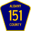
County Highways | Each of the State's 62 counties, except the five boroughs of New York City, has its own highway system. Each is a little different, either in its numbering system, the extent of its coverage, or in other aspects. And each will one day (hopefully) have its own listing on this site. Here you will find the ever-growing list of county highway pages completed so far. |

|
Reference Routes | Most reference routes are state highways like any other, except that they are not marked as touring routes for use by the motoring public. The New York State Department of Transportation (NYSDOT) also assigns reference route numbers to facilities maintained by other state-level agencies (such as the New York State Thruway Authority). A brief treatment is given of the numbering system and characteristics of these roads, which are listed here for the first time on the Internet. |

|
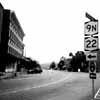
Little Green Signs | This section deals with the reference marker system of New York State. It describes the meaning and placement of the markers on various types of roads. Regulations concerning reference markers were revised a few years ago, and were outlined in the Reference Marker Manual published by NYSDOT for use by Region officers and crew. Please note that this information comprises the current official standard for the system. However, existing markers follow a variety of older practices, and it will be some time before a majority of the State's roads conform to all of the new guidelines. |
| SPECIAL FEATURES | ||
|
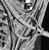
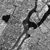
Interchange of the Week | Our most popular section features weekly installments of aerial photographs, accompanied by descriptive commentary, depicting complex or unusual highway interchanges around the State. The photographs used are available to the public for browsing and download through the Orthophotoimagery Program at New York State GIS. Several of the terms and interchange types encountered in this section are discussed in Kurumi's Field Guide to Interchanges. |
|
New York Highway Travelogues | Each of these four narratives describes the scenery and general character found along the length of one of New York's many numbered touring routes. Interesting features along the way, road related and otherwise, are pointed out, and numerous illustrative photographs are included. |

|
Photo Galleries | For many, the most alluring thing about roads is simply that they go places, and these photo galleries capture some of those places. You will find photos not only of roads and related features such as signs, bridges and interchanges, but also of the many beautiful and interesting sights and experiences to which the roads lead. |
|
Aerial Photos & Maps | Included in this section is a collection of orthophoto image mosaics, the newest offering from Empire State Roads. These extraordinary color-enhanced aerial views, compiled from New York State GIS orthophotoimagery, provide a fascinating look at the Empire State from above. Also included are a few conventional maps, each showing a different aspect of New York State's political structure (counties, towns, villages etc.). These have been created exclusively for this website and may be reproduced and used elsewhere only with the express permission of Empire State Roads. |
Other features
Empire State Roads Quiz
(Courtesy of www.kurumi.com)
After reading the three Road Facts sections, you'll be ready to play "Who
Wants To Be A Millionaire?" the Empire State Roads way. Almost all of
the answers can be found within these pages; they encompass a number of
vital (?) facts that every hardcore New York State road scholar will want
to brush up on. This version of the game was created by Scott "Kurumi" Oglesby,
whose challenge to the road scholars' community to submit quizzes has been
answered by several of its dedicated members--be sure to try the others
too.
ESR In The News
This site's webmaster was featured in the Rochester Democrat and Chronicle on
May 21, 2000. View the photo and read an excerpt from the article here.
NYS Highway and Map Links
A selection of highway sites related to the roads of New York State are
linked here. Also included are access to online maps of the state and links
to map companies whose products are recommended by the webmaster.