
County Highways
Reference Routes
Little Green Signs
Special Features
Interchange of the Week
Maps
Home
What's New?
Links
Contact ESR
Visitors since 02/09/01

View Guestbook
Sign Guestbook
Orthophoto Image Mosaics
 About
orthophotos
About
orthophotos
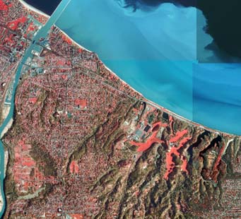
These images present a brilliant view of the Earth from above, but they
also offer the positional accuracy of a map. Orthophotos are aerial or
satellite images that have been rectified to eliminate distortion
caused by camera tilt and ground elevation differences. The orthophotos
used here are freely available to the public from the New York State
GIS (Geographic Information Systems) repository. For more
detailed information on these images, please visit the preceding link.
About the mosaics
The orthophoto mosaics available at Empire State Roads are composed of
individual orthophoto tiles, downloaded from the GIS repository, that
have been assembled to form larger images. In cases where NYSGIS
orthophotos have been restricted from online usage, USGS imagery,
obtained through TerraServer
USA, is used instead. This imagery is usually identical to
that compiled by NYSGIS, except that it is presented in a panchromatic
(black-and-white) format rather than color-infrared. The orthophoto
mosaics are provided in two formats: quadrangle-based mosaics and
metropolitan area mosaics.
The quadrangle-based images cover an area of 7.5 minutes of latitude and longitude, corresponding to the quadrangle maps published by the United States Geological Survey and the New York State Department of Transportation. Each quad consists of sixteen tiles, although certain mosaics contain extra tiles where the image area extends across the quadrangle edge. Furthermore, tiles may be missing for large areas within a quadrangle lying outside of New York State. The mosaics are presented at a resolution of 8 meters per pixel, reduced from the original 1 meter resolution of the tiles. Actual map scale will vary depending upon the user's display settings. The quadrangle-based mosaics are essentially the same format as USGS orthophotoquads, although they lack the minimal cartographic treatment found in the latter.
The metropolitan area mosaics are made up of whole or
partial quadrangles, usually presented at 16 meters per pixel (one-half
the
size of the quadrangle-based mosaics, or one-sixteenth the size of the
original tiles). Because of their lesser resolution, the metro area
mosaics show a larger ground area in a proportionately smaller file
size than the quadrangles. The metropolitan area images show the
immediate vicinity of a major city or larger metropolitan area in New
York State. Some of these mosaics have been augmented with USGS imagery
to show adjoinging areas outside of the State.
About the files
The images are presented in high-quality JPEG format (.jpg) and
generally range in size from 1 to 2.5 megabytes (for comparison, each
original orthophoto tile in MrSID format is approximately 1.5
megabytes).
Because of the large file sizes, it is recommended that users download
the files to their hard disk, using the "Save As..." command in their
browser. Images can then be viewed offline in the browser or a graphics
viewing program. The images are in the public domain and may be used
and distributed free of fees or licenses of any kind. It is merely
requested that the New York State GIS, USGS and Empire State Roads web
addresses be retained along the edge of the image, as a means of credit
for the base imagery and mosaicking procedure.
Download orthophoto image mosaics
Quadrangle-based | Metropolitan AreasNew York State Maps
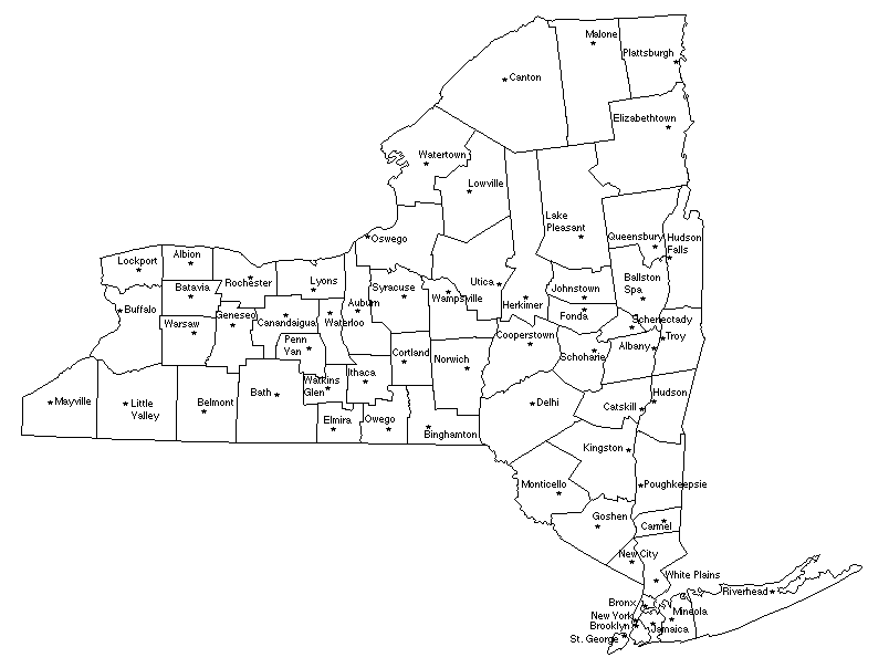
Counties: This map shows boundaries and names for all 62 counties in New York State. Clicking on a county will take you to the Empire State Roads route listing for that county.
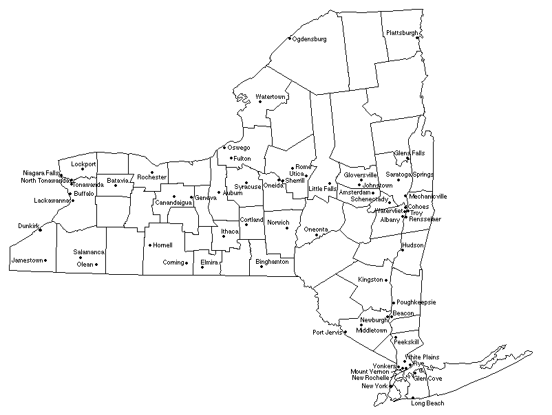
County Seats: This map shows the seat of government for each county. This is usually a City or Village, but a few are unincorporated localities; one county's seat (Warren) is considered to be a Town (Queensbury). Although the main county offices may not be located precisely within the municipality named, these are nevertheless the official, or traditional, county seats.
Cities: New York State has sixty-two Cities, shown here. They range in population from less than three thousand to over seven million, although most are between ten and thirty thousand. Cities are not the only large municipalities in the State: the largest Village, Hempstead, is more populous than all but twelve of the true Cities, and a few unincorporated places are larger still. Also available is a list of all the Cities, arranged by population (1990 census).
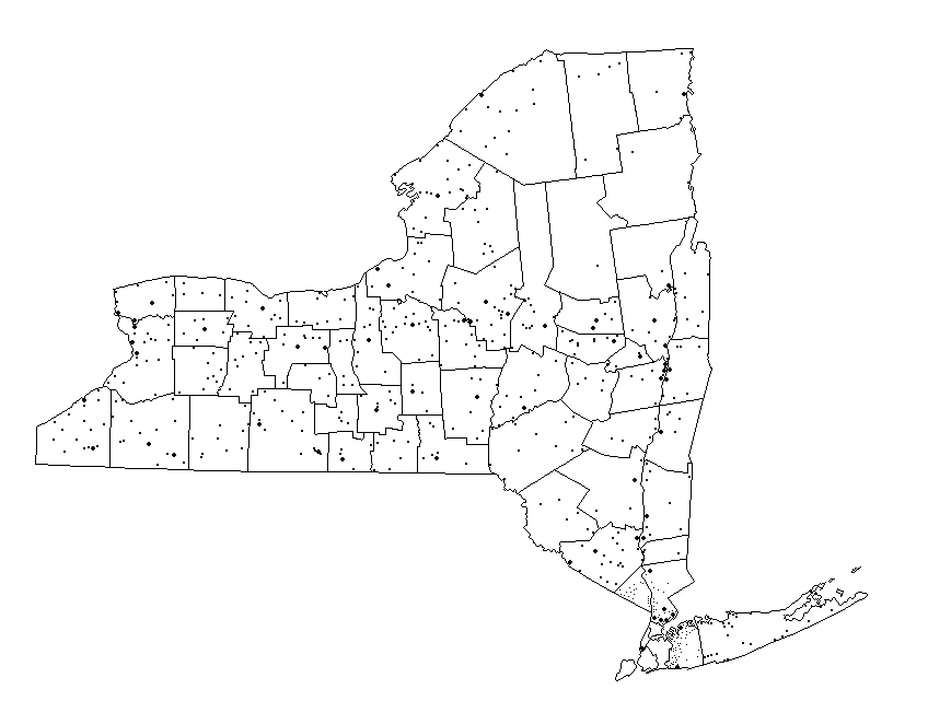
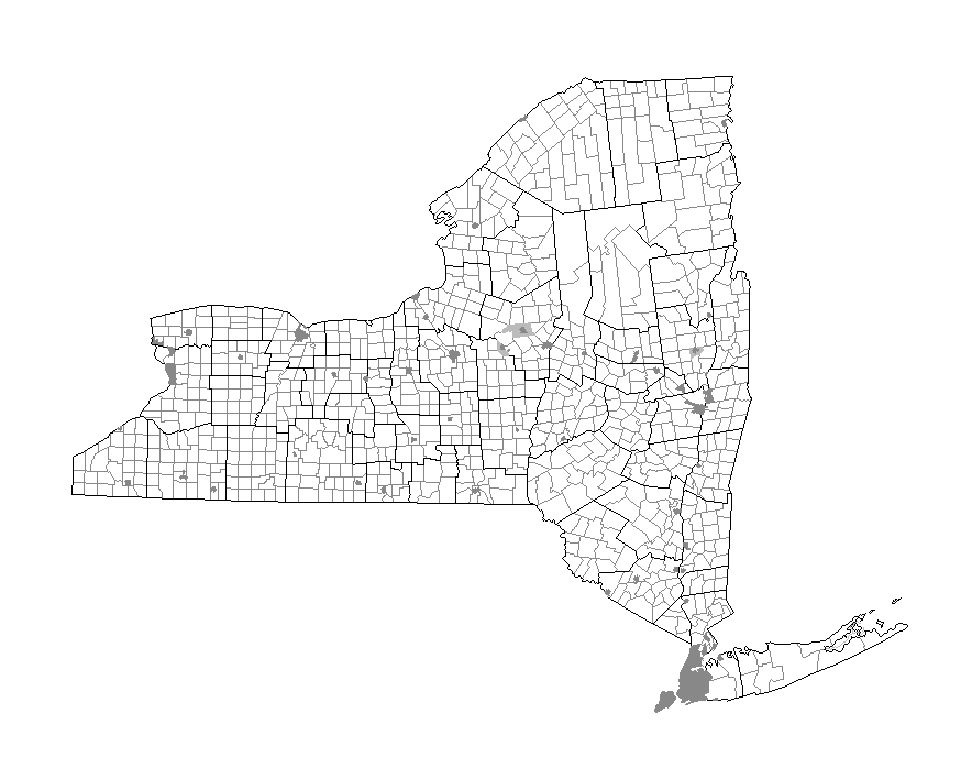
Villages: As of 1998 there are 554 incorporated Villages in New York. This map locates each with a dot (larger dots show Cities, smaller dots are used for villages in Rockland, Westchester and Nassau Counties because of scale). Four of the Villages in the State are coterminous with Towns and have special combined forms of government. Villages range in population from 28 persons (Dering Harbor) to nearly fifty thousand (Hempstead); most contain between 250 and 1,000 persons with larger villages reaching 5,000 or more.
Towns: All of the land in New York State lies in either a Town or a City, never both. While not all counties contain Cities, all except the five boroughs of New York City do contain Towns, and these are outlined on the map. Cities are shown on this map by a grey tint, with lighter grey depicting the lower tax areas of the Cities of Oneida, Rome and Saratoga Springs (this functions like a City surrounded by a Town, with the government of the two merged to form a single entity).