

Road Facts
County Highways
Reference Routes
Little Green Signs
Special Features
Interchange of the Week
What's New?
Links
Contact ESR
Visitors since 02/09/01

View Guestbook
Sign Guestbook
LITTLE GREEN SIGNS
Reference marker legend
Reference marker legends consist of three rows of numbers and letters, with each row having four positions. The top row may contain less than four characters but the middle and bottom rows always have all four spaces filled. In modern markers, all characters are two inches in height. On older markers, many of which still remain, the middle and bottom rows are much smaller than the top. These are usually difficult to read and are furthermore not reflective.
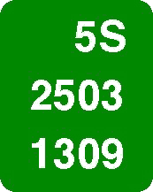
Top row: This is the route designation. The first three spaces carry the numerical portion of the route designation (one to three digits) and the last space carries the alphabetic suffix, if any. If the route number is only one digit, this digit is placed in the third space from the left; a two-digit number starts in the second space. Thus the numerals are always adjacent to the alphabetic suffix.
The route designation given on markers is often different from the actual touring or reference route number. Sometimes a route has been absorbed by another route, or has been relocated on a new alignment and a new route designtaion placed on the old alignment. Also, a touring route may have been decommissioned and parts of it reassigned as reference routes. In many of these cases, reference markers show the older route numbers because the markers are usually only replaced as part of a major maintenance or construction project.
Middle row: The first digit gives the Region number. NYSDOT divides the State into 11 Regions, which are jurisdictional divisions. For Regions 1 through 9, the appropriate numeral is used. For Region 10, the numeral 0 is used, and for Region 11 the letter X is used.
The second digit is the county code. The counties are arranged alphabetically within their respective Regions and assigned numbers according to this listing. The first two digits combined therefore give a unique code to each of the 62 counties.
The third and fourth digits give the county order number. This number begins with 01 at the south or west terminus of the route and increases by one each time a county line is crossed. If a route enters and leaves a county more than once, each crossing is counted. [In Region 11 (New York City), this number is expressed only by the last digit in the middle row. The third digit will then be M for mainlines and C for collector-distributor roads.]
Bottom row: The first digit is the control segment number. A control segment is a division of a route within a county, and is almost always measured by city lines. At each county line, the control segment number is reset to 1 and increases with each city line crossing (again, repeated crossings are counted separately). In the case of the three cities (Saratoga Springs, Rome and Oneida) that have high and low tax boundaries, the control segment theoretically changes only at the low tax (outer) boundary. On existing markers, however, this digit changes only at the high tax (inner) boundary.
[This digit has a different meaning in Region 11 since the entire Region lies within a single city and thus control segments are meaningless. Instead, this digit gives the direction of travel, with north, south, east and west being represented, respectively, by 1, 2, 3 and 4.]
The last three digits of the bottom row are sequencing numbers. These at first seem to be distances in tenth-miles from the beginning of a control segment, but in fact are determined in a slightly different way. They are taken from the actual milepoint at which the marker is placed in the direction of inventory (that is, from south to north or from west to east), expressed in hundredths of a mile. The hundredths figure is dropped and the decimal point removed, giving a three-digit number increasing from 000 at the beginning of a control segment.
NYSDOT expressly notes that reference markers are not to be construed as exact measurement devices due to the variations in placement described above and on the previous page.
One-way Couplets: A one-way couplet is formed where a route follows different roads or streets in each direction of travel. In this case the westbound or southbound direction is indicated by the letter V in the second space of the bottom line. Sequencing numbers on this section begin at the western or southern junction of the two directions and increase in the same direction as on the main section. This means that the numbers decrease as viewed by motorists travelling the so-called "opposite" direction. This also means that there may be more or fewer markers in one direction due to different alignment lengths.
Panel legends and marker placement vary on roads other than mainline highways. A description of these differences begins on the next page.