Interchange of the Week
Monday, 24 November 2003
Monday, 24 November 2003
New York State Thruway - Exits 27-29,
Amsterdam-Canajoharie
 |
|
|
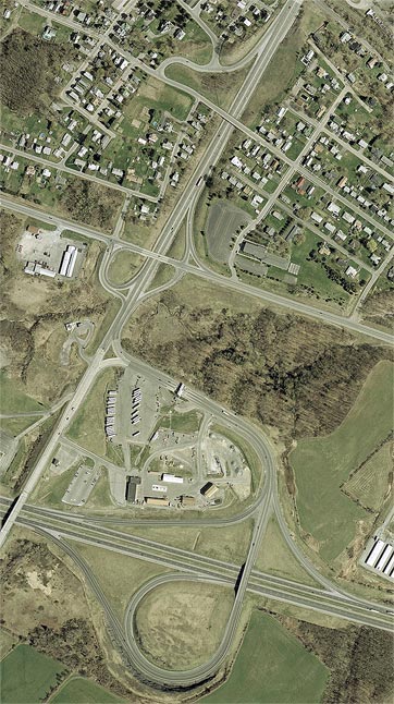
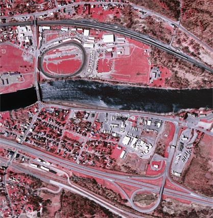
Orientation: Interstate 90, the New York State Thruway, runs from left to right at bottom; NY 5S runs across the center. NY 30 runs from bottom to top. Perkins Street enters at top left, becoming Grieme Avenue as it crosses NY 30.
Exit numbers: Exit 27 on the New York State Thruway is for NY 30 to Amsterdam.
The interchange: The Amsterdam interchange on the New York State Thruway connects to the NY 30 arterial that feeds that city from the south. NY 30 has several interchanges of its own in Amsterdam, including the two shown here. Just north of the Thruway interchange is a folded diamond with NY 5S, which bypasses several of the Mohawk River towns on relatively new alignments like the one it follows here. There is also a single exit ramp from NY 30 southbound to Perkins Street and Grieme Avenue. This ramp also intersects Florida Avenue, which is part of the original alignment of NY 5S. Two more interchanges lie to the north on NY 30, and are featured in Week 9.
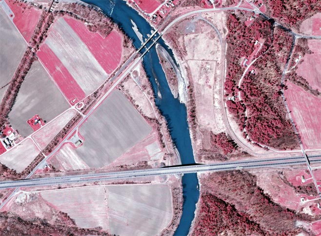
Schoharie Creek Bridge: The New York State Thruway crosses Schoharie Creek near Fort Hunter. The original bridge at this location collapsed during a severe flood on April 5, 1987, killing ten motorists. Shown above is the present Thruway bridge, as well as the NY 5S bridge and an abandoned railroad bridge just north of the Thruway. The latter two structures were used to carry Thruway traffic during reconstruction of the collapsed bridge; during a later stage, NY 5S used the railroad bridge while I-90 westbound used the NY 5S bridge. Notice that there are stretches of pavement to either side of, as well as on, the railroad bridge (see photos). East of the creek, the temporary roadway that connected the Thruway to these bridges is still clearly visible. The portion of the roadway west of the creek, however, is not to be traced today.
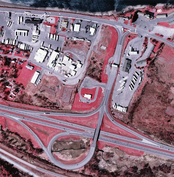 |
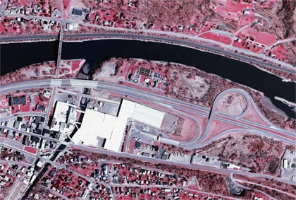
Orientation: The New York State Thruway (I-90) is at bottom, and Riverside Drive (reference route 920P) is at top, alongside the Mohawk River. Glen Drive and NY 5S are the closely parallel roads at bottom left.
Exit numbers: Exit 28 on the Thruway is for NY 30A to Fultonville and Fonda.
The interchange: Although this exit is signed for NY 30A, the interchange does not actually intersect that route. Rather, it meets Riverside Drive, an unmarked state highway, just outside the Village of Fultonville. This road runs west into Fultonville (see overview) where it meets NY 30A, which runs to the south, toward NY 5S, or to the north, over the Mohawk River to the county seat of Fonda. Riverside Drive, at its east end, also meets NY 5S.
The actual trumpet roadway intersects Riverside Drive at a T-intersection with channelized right turns. By contrast, the Exit 27 ramp meets NY 30 at a two-legged Y-intersection.
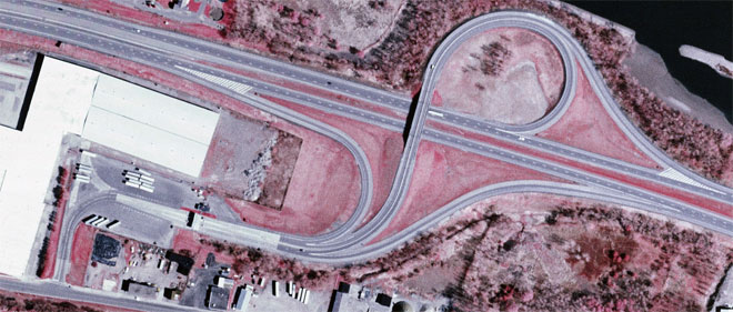 |
Orientation: The Thruway runs from top left to right. NY 5S is at bottom left.
Exit numbers: Exit 29 on the Thruway is for NY 10 to Canajoharie and Sharon Springs.
The interchange: Like at Fultonville, this interchange is signed for a route it doesn't intersect. Because the Thruway crosses through the center of these two Mohawk villages, it was not practical to locate interchanges directly at the cross routes in congested downtown areas, but rather with a highway parallel to the Thruway on the outskirts of town. In this case, the ramps meet NY 5S, which then leads westward to NY 10 in downtown Canajoharie (see overview). Another peculiarity is that the trumpet connector curves sharply to the south, at a point where an old Y-intersection is discernible. This would have connected to a former through street, which has since been cut off by a building of the Beech-Nut company.