Interchange of the Week
Monday, 22 January 2001
Monday, 22 January 2001
I-790, NY 5, NY 18, NY 12 & NY 49, Utica
 |
| A full-size image (256 kb) is also available. |
|
|
| A full-size image (256 kb) is also available. |
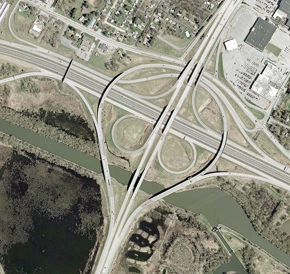
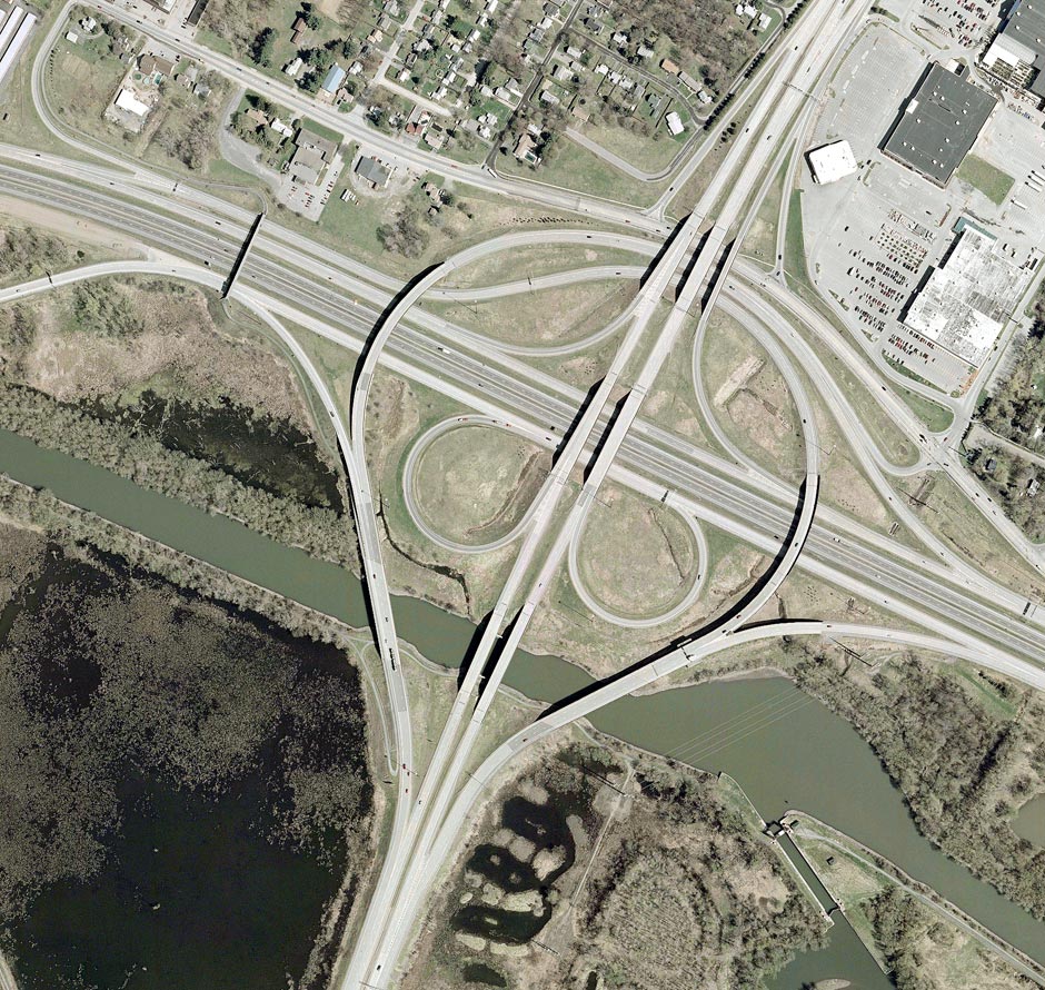
Orientation: Utica's North-South Arterial runs top to bottom, carrying the overlapping designations of NY 8 and NY 12. From left to right, four parallel carriageways traverse the picture. The inner two of these roadways, darker colored in the photo, carry the New York State Thruway (I-90). On the outer two roadways, NY 49 (the Utica-Rome Expressway) enters from left and ends at the eastern edge of the interchange. At far left, a stub of pavement indicates where NY 49 today continues west on the recently-extended Utica-Rome Expressway, remaining immediately parallel to the Thruway. The southward curve from the stub, which connects to Edic Road at its junction with River Road, is one of a pair of new ramps between Edic Road and NY 49.
NY 5 overlaps Interstate 790 for the latter's entire length; they enter here at bottom, together with NY 8 and NY 12 on the North-South Arterial. At the interchange, they turn ninety degrees, exiting the photo at right on the two outer roadways (continuing the path of NY 49).
The surface road running from left to right is River Road, also known as Utica's Northside Arterial; this road formerly carried the NY 49 designation and is now a county highway. The Erie Canal runs across the bottom, and at lower left is the entrance to the Barge Canal terminal basin. A guard lock can be seen here, necessary because the channel crosses the waters of the meandering Mohawk River, just to the south.
Exit numbers: Exits are not numbered on Interstate 790, nor any of the NY route freeways in this area.
The interchange: This junction is a fairly normal 8-ramp freeway to freeway interchange, designed to favor movements to and from the south. A result of this is that through traffic on I-790 (and NY 5) is provided with higher speed connections than certain other paths. High-speed ramps also serve traffic between NY 49 (to the left, towards Rome) and points south (central Utica). Note that the northbound entrance ramp meets not the mainline of NY 8/NY 12, but a service road that begins just at this point, merging back onto the mainline two or three miles to the north.
Interestingly, the New York State Thruway passes through the midst
of the interchange without any connections. Instead, the Thruway has an
indirect connection to I-790 and NY 5 at
Genesee Street, just east of
here. Furthermore, ramps connect the North-South Arterial with River
Road. The ramps to and from the north form a standard "half-diamond",
with the northbound entrance ramp joining that from I-790/NY 5 and
connecting to the northbound service road. An entrance to the Riverside
Mall branches off from this service road. The ramps to and from the
south are located some distance in either direction from the Arterial.
They are connected to the high-speed ramps leading to and from the
south, meaning that they are not available to traffic on the east-west
freeway. Connections with the latter can be made at the Edic Road
interchange, just left of this picture.
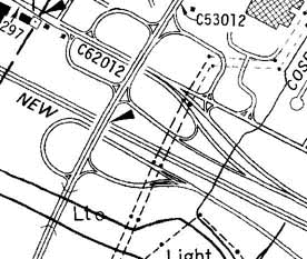 The
old interchange:
The
old interchange:
This interchange was completely rebuilt and expanded in the mid-1980's
to improve connections, to prepare for the building of the Utica-Rome
Expressway, and to upgrade I-790 to more modern standards. This map of
the interchange from 1978 shows its previous configuration. Here, the
Thruway and the North-South Arterial are depicted more or less as they
exist today. However, I-790 and NY 5 are not overlapped, and do not
flank the Thruway as they do now, but rather follow separate highways
on either side of the Thruway. I-790 runs along the undivided roadway
just south of the Thruway, joining the North-South Arterial at a highly
archaic interchange featuring tight, two-way ramps and even
cross-traffic. NY 5, on the other hand, follows a divided highway along
the Thruway's north side before being shunted onto River Road. Its
junction with the North-South Arterial is a similarly archaic form, a
type of cloverleaf with undivided ramps.