Interchange of the Week
Monday, 30 July 2001
Monday, 30 July 2001
NY 440 & Korean War Veterans Parkway, Staten
Island
Outerbridge Crossing
 |
|
|
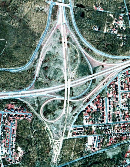
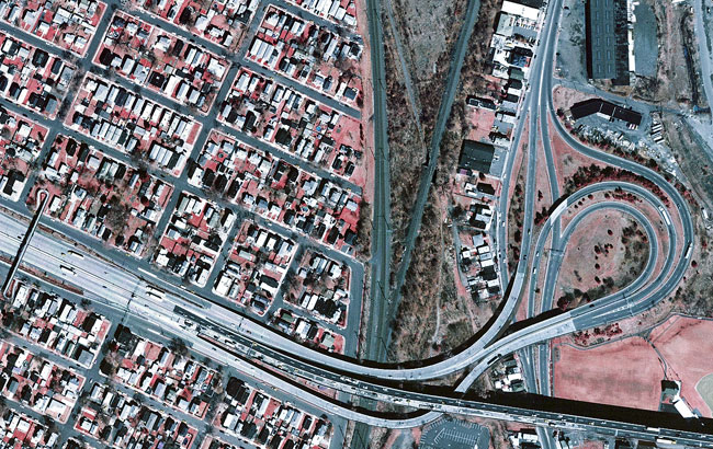
Orientation: NY 440 enters at left and exits at top on the West Shore Expressway. The Korean War Veterans Parkway (formerly the Richmond Parkway) runs toward the right.
Exit numbers: This interchange is signed as Exit 2 from both
NY 440 and the Korean War Veterans Parkway. 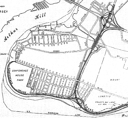
The interchange: The interchange shown above is the
southernmost in New York State, located near Tottenville on the
southwestern tip of Staten Island. The interchange is unfinished,
having been designed to serve Shore Front Drive, a highway once
intended to run south from here. The interchange, if fully completed,
would be of a partially "unfolded" full cloverleaf design, with flyover
ramps favoring through traffic on NY 440. In its present state, the
connection from NY 440 southbound to the Korean War Veterans Parkway
follows quite a circuitous route, as it uses part of the through
roadway from the West Shore Expressway to Shore Front Drive. Some of
the unopened ramps in the photo have since been put to new use with the
construction of a Park & Ride facility on the south side of the
interchange.
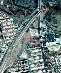
The image at right (click to enlarge) shows the western end
of Shore Front Drive as originally planned. Its interchange with the
Conference House Spur would have been the state's southernmost if
constructed. Note that the design of the West Shore Expressway
interchange differs in the plans from what was eventually built, with
the retained loop ramps lying on the opposite side of the interchange.
Image provided courtesy of Steve
Anderson
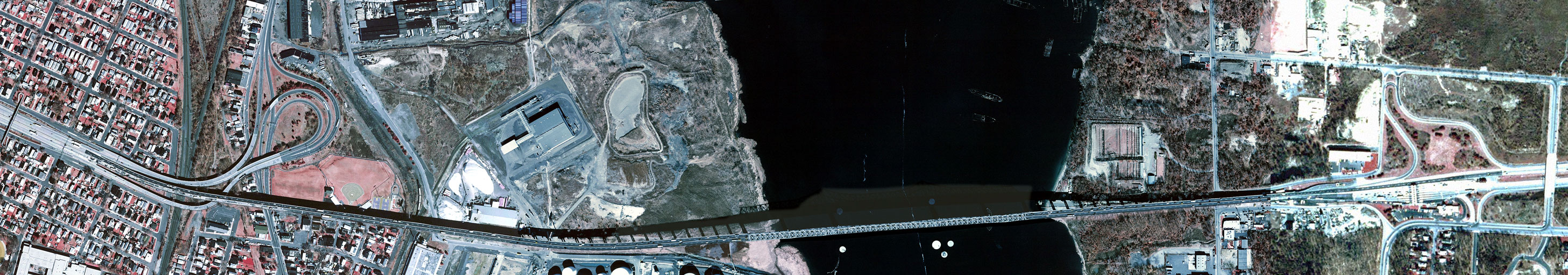 |
Just to the west of the featured interchange, the Outerbridge Crossing spans Arthur Kill between Staten Island, New York and Perth Amboy, New Jersey. At the New York end (right) is Exit 1 from NY 440. Southbound (towards the left) the exit is marked for Arthur Kill Road, which runs along the left edge of the photo. However, the ramps actually intersect Veterans Road. From northbound NY 440, the exit is for Page Avenue (bottom). Also on the New York end of the bridge is the toll plaza, where fare is collected from northbound travellers only.
 The
photo at left (click to enlarge)
shows the first New Jersey interchange
(actually the last, since it is available only to traffic leaving New
Jersey). This is a modified "trumpet" interchange for State Street,
where the southbound entrance is taken around the loop instead of
following the usual, more direct path, and where both southbound ramps
join State Street inside its spread median. The ramps to and from the
west join not only the NJ 440 freeway but also its service roads: Grove
Street on the south side and Lawrence Street on the north.
The
photo at left (click to enlarge)
shows the first New Jersey interchange
(actually the last, since it is available only to traffic leaving New
Jersey). This is a modified "trumpet" interchange for State Street,
where the southbound entrance is taken around the loop instead of
following the usual, more direct path, and where both southbound ramps
join State Street inside its spread median. The ramps to and from the
west join not only the NJ 440 freeway but also its service roads: Grove
Street on the south side and Lawrence Street on the north.
New Jersey imagery from New Jersey
Office of GIS.
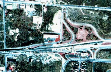
 At the
other end of the Korean War Veterans Parkway, traffic is shunted onto
and off of the divided roadway, which continues beyond a short distance
to an unused overpass of Richmond Avenue. The Richmond Parkway was to
have extended northward through La Tourette Park to the Staten Island
Expressway, where another unused interchange exists today. At the stub
shown here, a section of Drumgoole Road, which forms a service road for
much of the parkway's length, connects the parkway with Richmond Avenue
to and from the north. Northbound traffic actually crosses the parkway
right-of-way to make this movement. There is also an exit from the
northbound parkway connecting to southbound Richmond Avenue at Gurley
Avenue.
At the
other end of the Korean War Veterans Parkway, traffic is shunted onto
and off of the divided roadway, which continues beyond a short distance
to an unused overpass of Richmond Avenue. The Richmond Parkway was to
have extended northward through La Tourette Park to the Staten Island
Expressway, where another unused interchange exists today. At the stub
shown here, a section of Drumgoole Road, which forms a service road for
much of the parkway's length, connects the parkway with Richmond Avenue
to and from the north. Northbound traffic actually crosses the parkway
right-of-way to make this movement. There is also an exit from the
northbound parkway connecting to southbound Richmond Avenue at Gurley
Avenue.