Interchange of the Week
Monday, 2 October 2000
Monday, 2 October 2000
I-490, I-590 & NY 590, Rochester:
The "Can of Worms"
The "Can of Worms"
 |
| A
full-size image
(337 KB) is also available. |
|
|
| A
full-size image
(337 KB) is also available. |
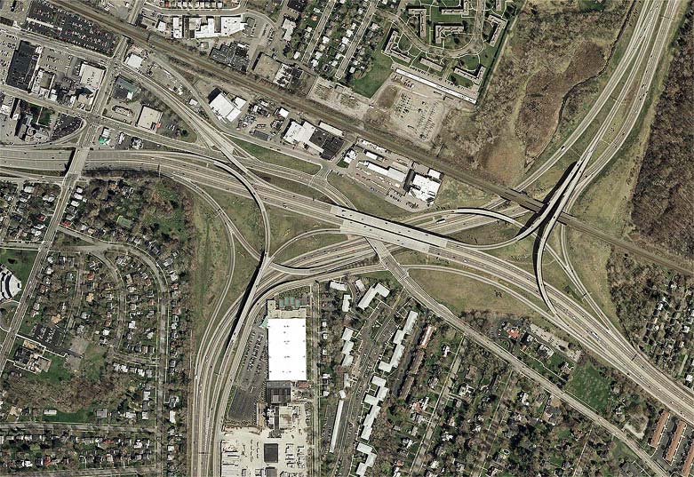
Orientation: I-490 runs left to right. I-590 enters at bottom left, changes to NY 590 at the double overpass (center), and leaves at top right. NY 96 (East Avenue) runs from bottom right to top left, passing over I-590 and under I-490 simultaneously. University Avenue enters at extreme top left, ending at a split at East Avenue. Winton Road is the diagonal north-south road at top left. The brown line is the CSX railroad mainline.
Exit numbers: This interchange marks Exit 21 on I-490 and Exit 5 on I-590 and NY 590. Half of I-490's Exit 20 is also within this interchange complex.
The interchange: This interchange is familiarly called the "Can of Worms", a name first applied to the original interchange at this location (see bottom photo). This was completely reconstructed between 1987 and 1991, resulting in the configuration shown above. The right-of-way limits of the old interchange are still visible in this picture, as is the embankment which once carried the ramp from I-490 WB to NY 590 NB, just to the right of the present ramp.
The new version provides semi-directional flyovers for all freeway connections, only one of which is a left-exit (from NY 590 SB). The "offset" configuration stems from I-590 and NY 590 having originally been completely separate roadways, each ending at I-490 in a directional T-interchange. Through traffic at that time had to enter I-490, weave through its traffic, and exit again on the opposite side. The weaving problems of the old interchange are not eliminated, but greatly reduced and relocated to lesser traffic locations. A weaving section now exists on I-490 EB, between the ramp from NY 590 SB and Exit 22 (Penfield Road). Another exists on I-490 WB, between the ramp from NY 590 SB and Exit 20, which is the ramp to University Avenue. Yet another exists on NY 590 NB, between the ramp from I-490 WB and Exit 6 (Blossom Road), partially visible at the top of the picture. Notice that, to avoid another weave, and to allow enough distance for a gentle climb to the flyover, the ramps from NY 590 SB are not available from the Blossom Road onramp. This is one of two connections that was sacrificed in the new design.
Local connections: Connections to and from local streets are also part of this complex. The half-interchange with Winton Road at the far left is part of I-490 Exit 20, comprising the eastbound offramp and westbound onramp. The westbound offramp is located within the Can of Worms itself, crossing over East Avenue and joining University Avenue up the middle as it splits to intersect East Avenue. (This left entrance, either by design or happy accident, facilitates access to Winton Road and East Avenue from University.) In the old design, this connection was by means of individual ramps from I-490 and NY 590; now, a single ramp serves both. The corresponding eastbound onramp for Exit 20 comes off of East Avenue and joins the ramp coming from NY 590 SB, which then merges into I-490. Note that access from this entrance is not possible to NY 590 NB, but it was possible in the previous version, again by means of individual ramps. This is probably the most serious flaw in the new design, as motorists wishing to make this connection must travel along surface streets to Blossom Road, or take I-490 east to Exit 22 and make a U-turn there. (Connections of East Avenue and Winton Road with I-590, to and from the south, are also unavailable, but this has always been the case. These connections are made at Exit 4 [Highland Avenue], just off the bottom of the picture.)
Complexities: There are a number of complexities that
contribute to this interchange to make it unique. First is the fact
that it is traversed by a major railroad, which passes over some
roadways and under others, in this as in the original configuration.
The required additional overpasses added to the visual tangle that
originally inspired the interchange's nickname. What today is a small
railroad spur just north of University Avenue was once a branch running
south from the mainline; it too had to pass through the old
interchange, but was abandoned by the time of the reconstruction,
simplifying the new design. (Its old right-of-way can be traced here,
along the left side of the large white building [a tennis club] and
crossing I-490 at about the point where the ramp from I-590 NB to I-490
WB does today.) Second, several side streets are in close proximity to
the highway. Gould Street, to the right of the tennis club, used to
extend farther north to intersect East Avenue literally in the median
of I-490. East Highland Drive, to the immediate right of I-590, had
been a dead-end street at the concrete block supply yard. It was
extended to East Avenue (see how tightly it curves between I-590 and
the tennis club) as part of the reconstruction, and Gould Street was
truncated to end at it. A small cemetery (the triangular green patch at
left
center), formerly tight against the soundwall, was given more breathing
space with the rebuilding. Still hard by the freeway are a cluster of
businesses on the south side of East Avenue east of Winton Road, and a
group of industries between University Avenue and the railroad. A most
impressive feature of this design was the ability to perform such a
major overhaul with minimal disruption to these surrounding features;
in fact, the new interchange fits almost perfectly within the space of
the old, while still meeting higher modern design standards. However,
the resultant confinement is very apparent on the ground: often, a
truck on the ramp from I-590 NB to I-490 WB appears headed directly at
eastbound traffic on East Avenue below.
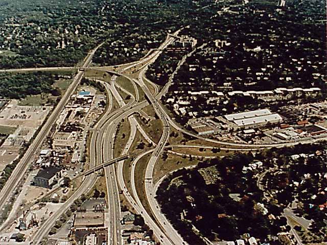 |
The old interchange: This photo is looking east over the
original Can of Worms, shortly after its completion. At that time
(mid-1960's), I-590 and NY 590 had not yet been designated; both were
instead part of old NY 47 until 1980. Notice that there were two
separate directional T-interchanges with I-490, and serious weave
conditions existed for through traffic in either direction on both
I-490 and NY 47. I-490 had a spread median to accomodate the left-hand
ramps, and the eastbound direction was elevated significantly above the
westbound, passing over what the latter passed under. Also note that
University Avenue did not end at East Avenue, but continued closely
parallel to it, intersecting both I-490 and NY 47 to and from the north
via the split ramps discussed above.
<< Back